To appreciate the importance of Newfoundland’s geological history in successful gold exploration, one must remember the following six facts about gold:
Fact 1.
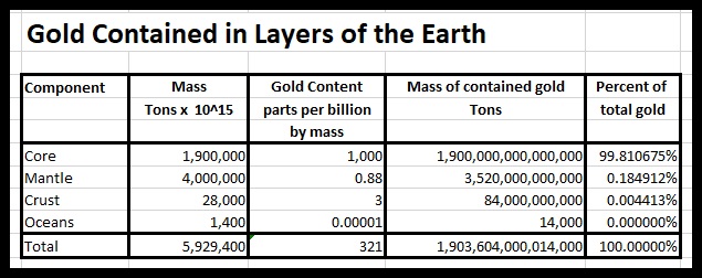
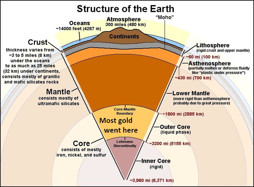
Gold normally resides within the upper mantle, lower mantle and core of the earth.
Fact 2.
Almost all economic gold deposits have been found within fault zones and shear zones.
Pathways from the earth’s mantle to crust must be created to bring gold up to the earth’s surface. These pathways are referred to as faults or shears. The collision of continental (tectonic) plates or their separation (referred to as rifting) creates faults and shears
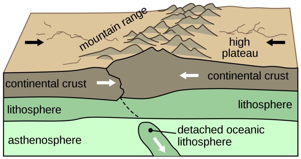
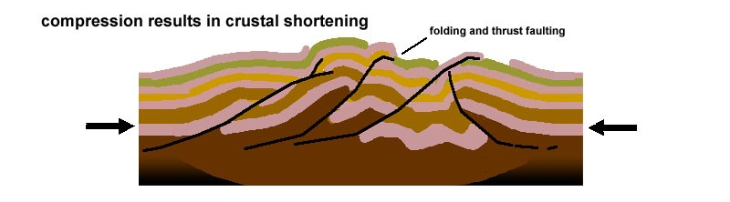
Fault zones and shear zones occur along the edges of continental (tectonic) plates, where the plates meet one another, or where an oceanic tectonic plate is weakened by rifting. The process of the continental plates moving against each other results in their edges folding and crumpling against each other, creating mountain ranges and volcanoes, and allowing gold bearing fluids to rise to the surface. During the course of each mountain building event (referred to as orogeny) new faults are formed, while older faults from the previous orogenies are reactivated.
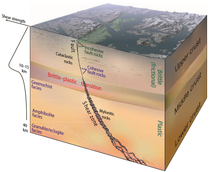
Fault: A fault is a vertical fracture between bodies of rock along which there has been significant movement one or both of the bodies Prolonged motion along faults progressively crushes the broken rock between the adjacent bodies creating a margin of crushed rock debris. The width of a fault can range from a few meters to several hundred meters.
Shear: If the fault continues from the brittle upper crust of the earth downwards into the lower crust and upper mantle of the earth, that portion of the fracture is generally referred to as a shear.
A fault zone or shear zone is a cluster of parallel faults or shears. However, the term is also used for the zone of crushed rock along a single fault if it is particularly wide.
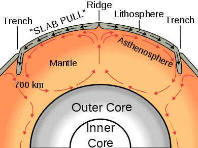
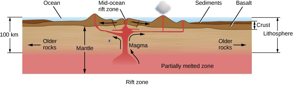
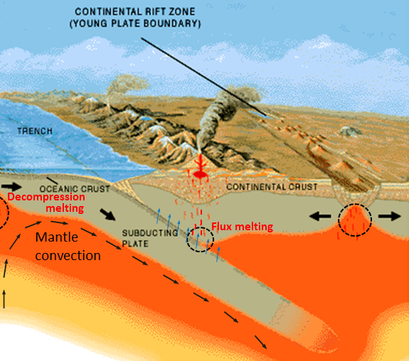
These openings in the earth’s crust (faults and shears) allow molten rock (magma) from the earth’s mantle to be pushed toward the surface by the higher pressure within the earth’s mantle. (Once magma reaches the surface it is generally referred to as lava).
Fact 3.
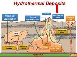
Hydrothermal fluids carry gold to the earth’s crust.
When rainwater or seawater that is descending from the earth’s crust, or water that is already trapped in the crust, comes into contact with the ascending magma, the water becomes and is superheated by it. (Water can be heated beyond 100 degree Celsius if under pressure. The greater the pressure, the higher the temperature water can obtain without being turned into a gas). This superheated water binds with gold and other minerals in the earth’s mantle and is forced upward under pressure into cracks, fissures (long narrow lines of breakage in rock) and cavities created in the earth’s crust, adjacent to the faults and shears. At these shallower depths the pressure is reduced, the water boils away and gold deposits are left, often encased in quartz rock. Along the intersections of near-vertical faults significant ore deposits are often discovered.
Fact 4.
Gold is found in mountain ranges.
Historically, more than three-quarters of the economic gold ore deposits that have been discovered by mankind were formed on the earth’s surface during the process of mountain building (orogeny) and have been located at the interface of continental plates where mountains ranges have been created.
Fact 5.
Erosion increases the concentration of gold.
Even if ancient mountain ranges have been weathered away through erosion, the majority of gold ore deposits remain, due to their weight relative to the surrounding rock. The ratio of gold to other rock increases under these circumstances. Determining the location of ancient mountain ranges and the fault zones associated with them can yield significantly rich gold deposits.
Fact 6.
The more fault and shear zones in a geographic location, the more likely you are to find gold ore deposits.
As our discussion below will illustrate, no mining jurisdiction in the world is home to more orogenic events and, therefore, more fault and shear zones in such a concentrated area than the Province of Newfoundland and Labrador.
2. Overview of the Province of Newfoundland and Labrador
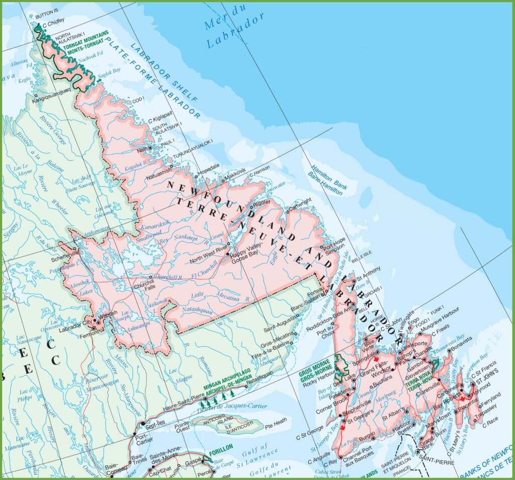
The land area of Newfoundland and Labrador (405,212 square kilometres) is approximately the size of the State of California and is larger than many countries in the world, Germany and England for example. The Strait of Belle Isle divides the province into two geographical components, Labrador to the northwest and the Island of Newfoundland to the southeast.
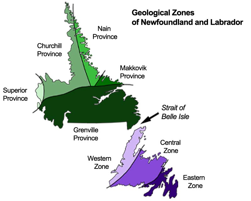
3. The Geological Zones of Newfoundland and Labrador
Geologically, the province is divided into different zones based upon their geological histories and the distinct rock types found within them.
The size and the borders of each region are defined by the occurrence of different geologic processes and there exist geologically significant boundaries between their underlying rock types.
Labrador is the easternmost part of the Canadian Shield.
The rock of the Canadian Shield is the oldest on Earth, primarily composed of Precambrian, igneous and metamorphic rocks. Covering an area of over 3 million square miles (8 million square km), the Canadian Shield is one of the world’s richest sources of mineral ores, including gold, silver, copper, nickel, iron and kimberlite diamonds.
Canada is the fifth-largest producer of gold in the world and possesses the world’s 9th largest gold reserves, the majorityof which are found in the Canadian Shield.
Two significant gold showings have been found in Labrador, the Aucoin Showing in North Central Labrador, and the VBE-2 showing just south of the Voisey’s Bay Ni-Cu-Co Mine. Both gold deposits are in the Nain Geological Zone
Despite Labrador having the geological potential of hosting substantial gold deposits, most gold exploration is now being focused on the Island of Newfoundland.
For this reason, we will focus primarily on the geology of the Island of Newfoundland.
The island of Newfoundland is the collision point of several continental plates that created a sequence of six major mountain building (orogenic) events. These mountain building events have created a vast network of gold bearing fault and shear zones concentrated within a relatively small geographic area.
The fact that all these ancient mountain ranges run through the island of Newfoundland makes the geology of the island unique in the world and has created one of the most prolific environments for gold exploration that can be found on our planet.
6. The Mountains of Newfoundland and Their Importance
Today’s gold exploration and gold discoveries are based on detecting and defining the location of these ancient mountain ranges and the fault and shear zones created by them.
A general understanding of the mountain building (orogenic) events described below will explain why exploration companies are acquiring exploration rights and exploring in specific areas of Newfoundland.
The five major mountain building events of the Island of Newfoundland are:
1. The creation of the supercontinent Rodina and the Grenville Orogeny (Occurring between 1.4 billion and 900 million years ago – the first source of gold ore).
2. The Rifting of Rodinia and the Creation of the Iapetus Ocean. (Occurring approximately 700 million years ago).
3. The creation of the Central Iapetus Magmatic Province (Occurring between 615 million and 550 million years ago – the second source of gold ore).
4. The Appalachian Orogeny
The Appalachian Mountains were built by three successive orogenic events:
The Taconic Orogeny (Occurring between 460 million and 440 million years ago – the third source of gold ore).
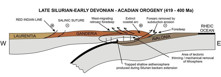
The Salinic (Ganderian)Orogeny (Occurring between 420 million and 400 million years ago – the fourth source of gold ore).
The Acadian (Avalonian) Orogeny (Occurring between 400 million and 360 million years ago – the fifth source of gold ore).
5. The Allegheny Orogeny and the creation of the supercontinent Pangea (Occurring between 290 million and 250 million years ago when all the major continents collided against each other – the sixth source of gold ore).
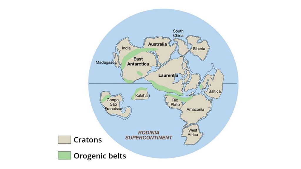
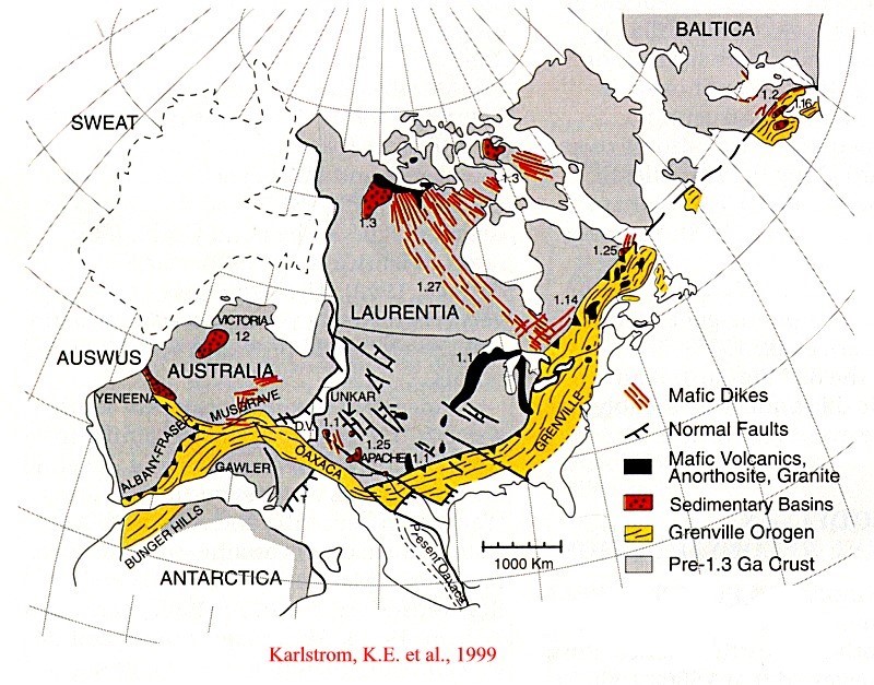
7. The Creation of Rodinia and the Grenville Orogeny
During a period estimated to be from 1.2 billion to 750 Ma (million years ago), all the continental (tectonic) plates on the earth were pulled toward each other by the underlying magmatic convection currents within the earth’s mantle. Over time the continental plates collided to create one “supercontinent” geologists have named Rodinia.
8. The Grenville Orogeny
As the continental (tectonic) plates of Rio Plata, Amazonia and Baltica collided with the eastern coast of Laurentia.The pressure on the earth’s crust caused by the compression of the (edges) of these tectonic plates against each other caused the crust to push upward, creating multiple fractures (shears) within both the crust and the underlying mantle.
These faults and shears (fractures) became pathways through which magma and hydrothermal gold-bearing fluids were pushed upward by the intense pressure of the lower crust and upper mantle.
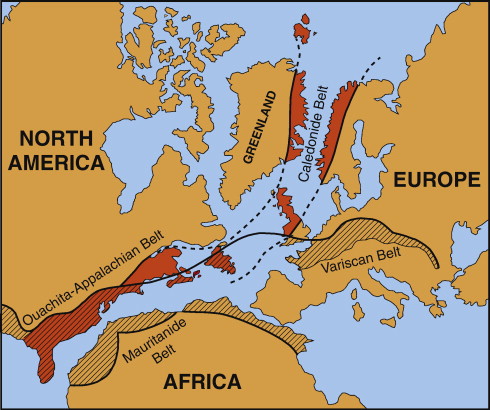
Along the eastern coast of the continental plate of Laurentia (the forerunner to North America) a mountain range was created. This mountain range extended from Scotland, through Labrador and Newfoundland and into the far southeast of the United States and Mexico.
This was first major significant mountain building event (orogeny) in Newfoundland and is referred to as the Grenville Orogeny. Geologists believe that the Grenville Mountain Range was similar to the present day Himalaya Mountain Range in scale and height. This mountain range forms the basement rockof today’s Appalachians.
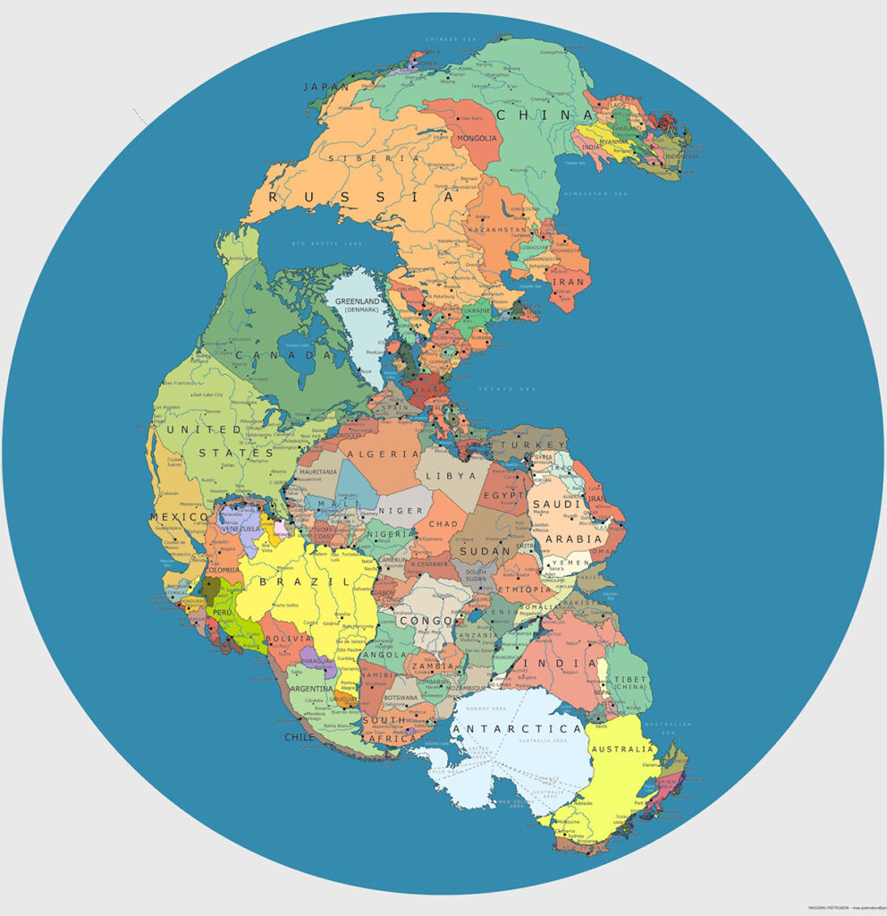
Note that the Grenville Mountain Range (marked in yellow) also runs through also Mexico and southern Australia.
Both areas are major gold producing regions of the world.
The Grenville Orogeny in Newfoundland
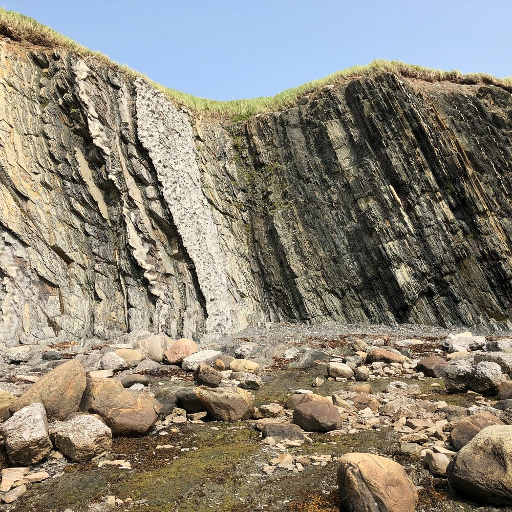
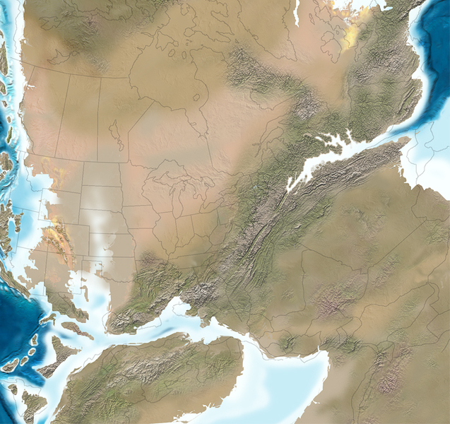
Today’s Appalachian Mountain Range still contains isolated exposures of the Grenville Orogen. The largest of these, the Long Range Inlier, constitutes the Long Range Mountains of Newfoundland.
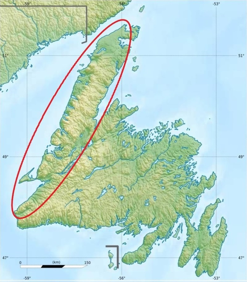
The Long Range Mountains are a chain of mountain peaks and high points located on the west coast of the island of Newfoundland on its Great Northern Peninsula. The range extends for about 400km (250mi) Starting on the southwestern edge of the island near Cape Ray and running toCape Norman in the northwest. The Long Range Mountains contains 288 mountains.The Cabox Mountain is its highest and most prominent mountain peak at 813m/2,667ft in height.
The Long Range Mountains comprise the most topographically rugged region of Newfoundland. The Long Range Mountains are bordered to the east by the rest of Newfoundland’s Canadian Appalachians.
The Great Northern Peninsula of Newfoundland, within which lie the Long Range Mountains, is outlined in red above. The image below illustrates the scale of the remnants of the Grenville Mountain Range.
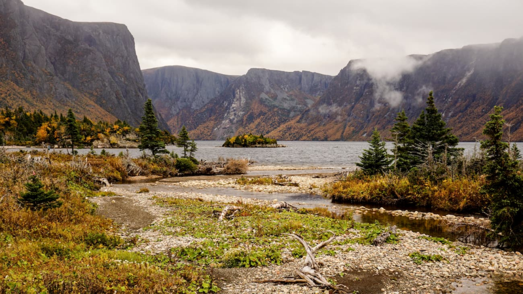
An example of the Long Range Mountains, part of the ancient Grenville Mountain Range, in North West Newfoundland
9. The Creation of the Iapetus Ocean and the Central Igneous Magmatic Province
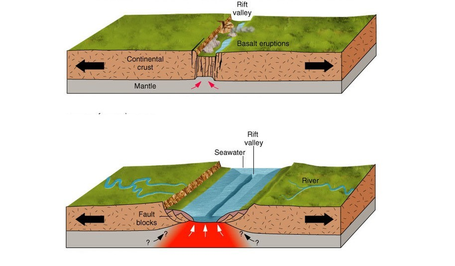
The Rifting of Rodinia
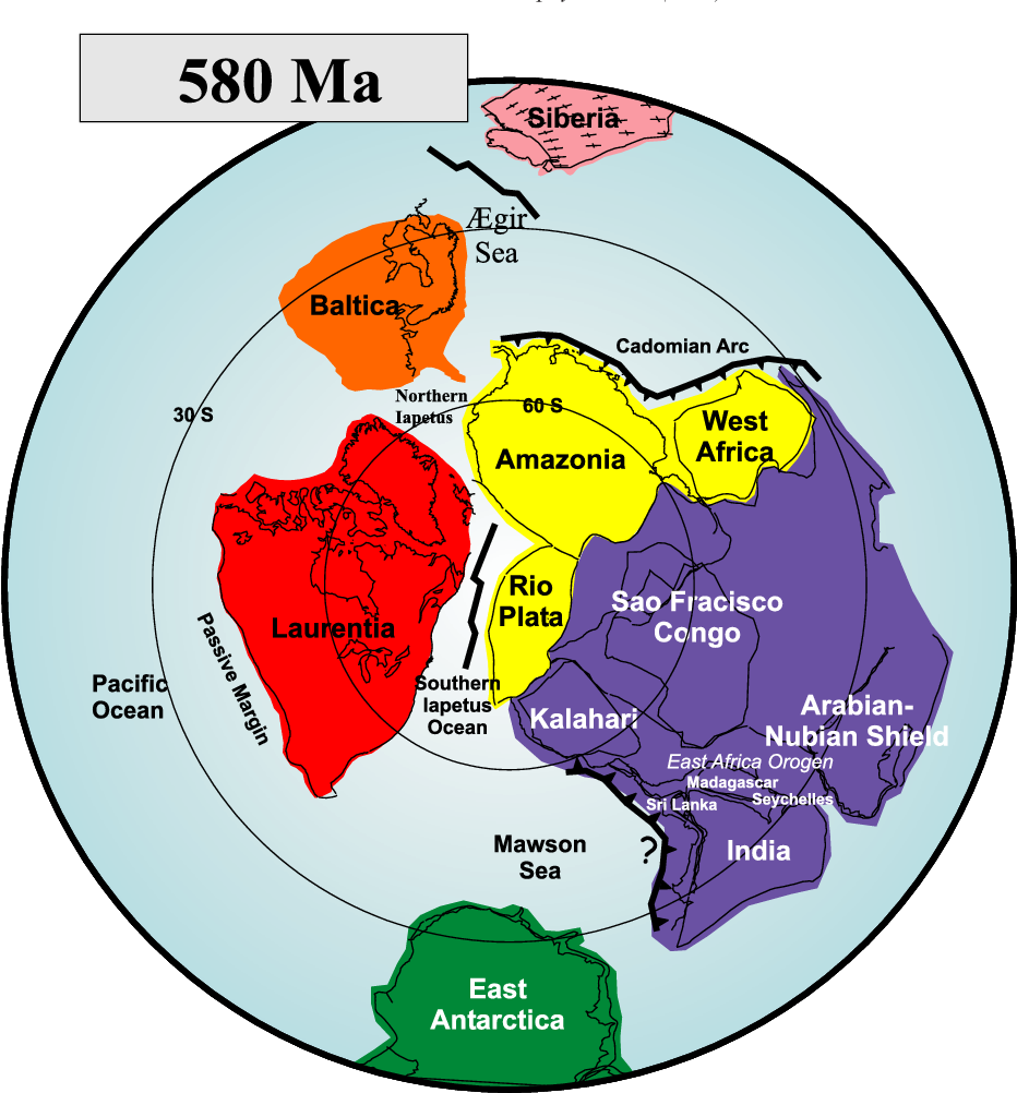
Between 700 and 550 million years ago, the magmatic currents underlying Rodinia changed directions. The continental plates that comprised Rodinia began to be pulled apart (rifting).
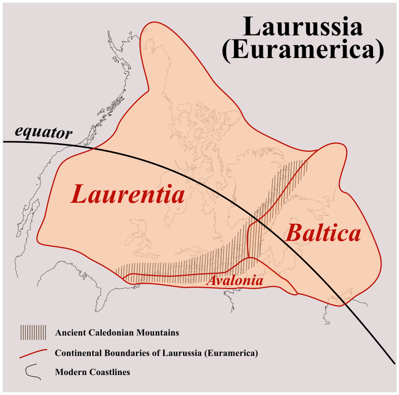
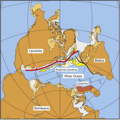
As the continental plates moved in separate directions, several continents (tectonic plates) were created, between which the Iapetus Ocean began to open. The IapetusOcean was situated between the continents of Laurentia, Baltica and Gondwana (the continental plates illustrated below in yellow and purple are collectively referred to as Gondwana.)
The GrenvilleMountain Range remained in Laurentia on its eastern coast line.
The rifting of the supercontinent of Rodinia resulted in three orogenic events that would subsequently have a significant impact on the gold bearing geology of Newfoundland. They are:
a) the creation of the microcontinent of Ganderia
b) the creation of the microcontinent of Avalonia
c) the creation of the Central Iapetus Magmatic Province
10. The Creation of the Microcontinents of Ganderia and Avalonia
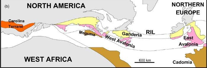
As the supercontinent of Rodinia broke up and the Iapetus Ocean increased in size, several volcanic island arcs were created. These island arcs were extensive, often stretching for thousands of kilometres. The two volcanic island arcs that had a direct impact on building mountain ranges in Newfoundland were Ganderia and Avalonia. (Read a more detailed account of Island Arcs and Microcontinents click here …)
The age of the rocks within each of these two volcanic island arcs demonstrates that they developed independently of each other and during different time periods. The age of the rocks found within remnants of Ganderia ranges from 1.2 ma to 800 ma. The age of the rocks within Avalonia range from 800 ma to 700 ma. These volcanic island arcs formed off the coast of Rodinia and moved along with the various other continental plates as Rodinia split apart.
These island arcs were extensive, stretching for thousands of kilometres.
These openings in the earth’s crust (faults and shears) allow molten rock (magma) from the earth’s mantle to be pushed toward the surface by the higher pressure within the earth’s mantle. (Once magma reaches the surface it is generally referred to as lava).em. Magma flowing up throughThese openings in the earth’s crust (faults and shears) allow molten rock (magma) from the earth’s mantle to be pushed toward the surface by the higher pressure within the earth’s mantle. (Once magma reaches the surface it is generally referred to as lava). earth’s crust was cooled by the ocean water and createdThese openings in the earth’s crust (faults and shears) allow molten rock (magma) from the earth’s mantle to be pushed toward the surface by the higher pressure within the earth’s mantle. (Once magma reaches the surface it is generaThese openings in the earth’s crust (faults and shears) allow molten rock (magma) from the earth’s mantle to be pushed toward the surface by the higher pressure within the earth’s mantle. (Once magma reaches the surface it is generally referred to as lava). moved toward the coastline of the newly formed continent of Gondawana. Eventually they collided with the west coast of Gondawana.
11. Docking With Gondwana
The Avalonian belt of volcanic islands first collided with Gondwana around 650 Ma. Ganderia subsequently collided with both Avalonia and Gondwana between 650 Ma and 565 Ma.
As illustrated here, as each microcontinent collided with Gondwana, more volcanic arcs were created and more folding and faulting of the margins of the tectonic plates occurred along the coastline of Gondwana.
Ganderia and Avalonia colliding with Gondawana
By 540 Ma, the Iapetus Ocean had formed between Laurentia and Gondwana and the movement of island chains towards Gondwana had stopped.
12. The Central Iapetus Magmatic Province
The Creation of the Central Iapetus Magmatic Province (615 Ma – 550 Ma)
As the constituent tectonic plates of Gondwana continued to diverge (rift), an increasingly large separation between these tectonic plates developed, creating a large shear through the earth’s crust into the mantle. The upward pressure of the magma flowing through the broken crust of the earth accelerated the process of rifting. This magma carried gold as well as copper, silver, nickel and iron upward from the mantle to the crust.
As the magma flowed up through the volcanoes it was pushed outward and away by the pressure of the magma following behind it. When the magma was subsequently cooled by seawater, it created a thick floor of igneous rock containing gold, copper, silver, nickel and iron. The igneous rock continued to expand and thicken as the continental plates of Laurentia, Baltica and Gondwana moved way from each other. This extensive bed of mineral rich igneous rock is referred to as the Central Iapetus Magmatic Province (CIMP). Geologists estimate the radius of the CIMP to have been 4,500 km (2,800 mi) and primarily located between the tectonic plates of Laurentia and Baltica.
Due to subsequent geological events, discussed below, the remains of the CIMP are to be found today in the Central Zone of Newfoundland.
13. The Closure of the Iapetus Ocean and the Appalachian Orogeny
The Appalachian Orogeny
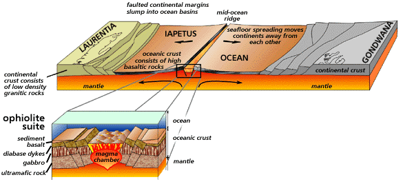
OVERVIEW: The closure of the Iapetus led to the collision of Laurentia, Baltica, Gondwana and the island arcs situated between them, thereby creating the Appalachian Mountains.
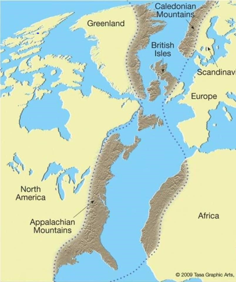
The Appalachian “orogenic belt”, is a mountain range that extends southeast from Newfoundland, Canada, for over 3,000 km (1,860 miles) along the eastern margin of North America to the state of Alabama in the southern United States.
To the north of the Island of Newfoundland the Appalachian “orogenic belt, continues to the north east through Ireland, Wales, northern England, eastern Greenland and Norway.
The Appalachian Mountains were formed upon the eroded base of the Grenville Mountains.
These mountain ranges likely once reached elevations similar to those of the Alps and the Rocky Mountains before they were eroded.
The Appalachian Mountainsstill contain small, isolated exposures of the Grenville Mountains. The largest of these exposures comprises theLong Range Mountainsof Newfoundland.
The collisions of Laurentia, Baltica, Gondwana, gave rise to three separate and distinct mountain building events, collectively referred to as the Appalachian Orogeny.
The Appalachian Orogeny consists of:
The Taconic Orogeny:commencing around 460 million years ago and finishing around 440 million years ago;
The Ganderian Orogeny:commencing around 440 million years ago and finishing around 425 million years ago;
The Avalonian Orogeny:commencing around 390 million years ago and finishing around 370 million years ago.
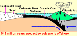
14. The Taconic Orogeny
a) The creation of the Taconic Island Arc
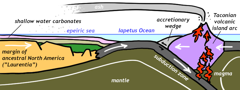
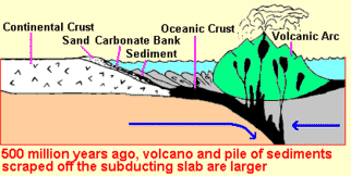
Between 550 and 515 million years ago, the convection currents within the mantle of the earth started to pull the tectonic plate underlying the continent of Laurentia eastward toward the continent of Gondawana.
The edge of the Laurentian tectonic plate extended much farther beyond its coastline, eastward under the Iapetus Ocean. The weight of the Iapetus plate pushed the Laurentian plate downward towards the earth’s mantle. Initially, the western edge of the Iapetus plate was pushed up and over the Laurentian plate.
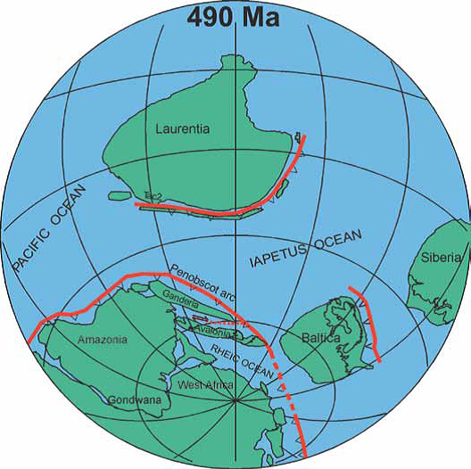
Around 490 Ma, volcanic mountains started to form above the subduction zone created by the collision of the Laurentian Plate with the Iapetus Plate.
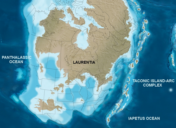
The result was the creation of a vast arc of volcanic islands referred to as the Taconian Volcanic Island Arc. The Taconian Volcanic Island Arc encompassed most of the eastern coast of Laurentia, including the coastline of Newfoundland and Labrador.
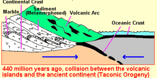
b) Collision with Laurentia : The Taconic Orogeny
The Laurentian tectonic plate continued to move eastward. Eventually it collided with the Taconian Island Arc between 460 Ma(million years ago) and 440 Ma million years ago. This collision is referred to as the Taconic Orogeny.
Because the Laurentian Plate was subducting below the Iapetus Plate, the island arc was pushed up and over the coastline of Laurentia. The floor of the Iapetus Ocean, which contained the mineral bearing rock of the Central Igneous Magmatic Province, was pushed up and upon the margin of the Laurentian plate by the advancing Taconic Island Arc.
The sedimentary rocks of the Iapetus Ocean and the igneous rocks of the Taconian Volcanic Arc were intensely compressed and folded as they collided with the Laurentian Plate.
Today, the remains of this island arc and the CIMP are found in the volcanic and intrusive rocks of the Central Zone.
(This fact becomes relevant in the discussion of the tectonostratigraphic zones of Newfoundland discussed below.)
The sedimentary rocks of the Iapetus Ocean and the igneous rocks of the Taconian Volcanic Arc were intensely compressed and folded as they collided with the Laurentian Plate. Multiple shear zones and fault zones were created within the sedimentary rock and igneous rock formations across the Island of Newfoundland, creating pathways for gold –bearing hydrothermal fluids.
c) Result and Size
The result of this collision was a mountain range stretching thousands of kilometers, from what is now Greenland southward into the south eastern United States. Based upon geological studies, the Taconian Mountain Range is estimated to have been a range in the scale of the Alps in Europe, with peaks exceeding 4,000 meters in height.
Over time the rocks of the Taconian Mountain Range eroded. The eroded rock created gold-bearing sediment that accumulated in adjacent low lying valleys on its westward side and in marine basins on its eastern side. The “roots” of the mountains and the gold ore deposits formed during the mountain building process remained in Newfoundland within what was to become the Appalachian Mountains.
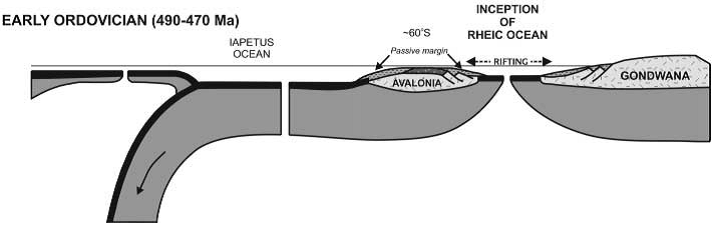
15. The Ganderian Orogeny
Rifting
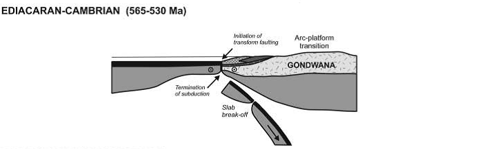
The volcanic island arc of Ganderia separated from the western coast of Gondwana around 565 and 530 Ma, when the subduction of the Iapetus Ocean under the continental (tectonic) plate of Gondwana stopped.
The tectonic plate underlying the Iapetus Ocean (the Iapetus Plate) began to subduct under the Laurentian tectonic (continental) plate, first pulling Ganderia and then Avalonia away from Gondwana toward Laurentia.
The separation of Ganderia and Avalonia opened the northernRheicOceanas ocean water flooded the separation between Avalonia and Gondwana. However, the geology of the Rheic Ocean was not to have any subsequent impact on the Island of Newfoundland.
(van Staal et al. 1998)
The Travel of the Microcontinents
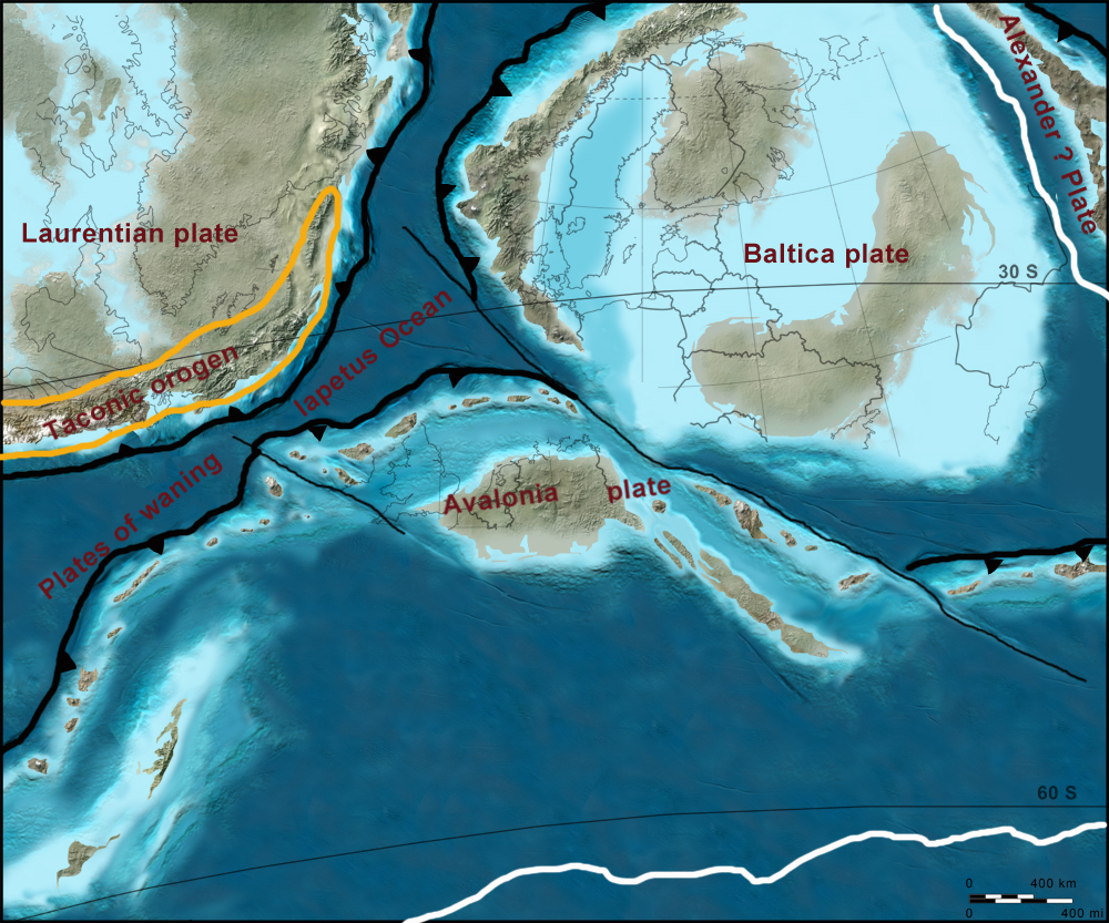
As the Ganderian “microcontinent” moved toward Laurentia and Baltica across the Iapetus Ocean, it spread across the Iapetus Ocean forming a wide arc of islands with western and eastern arms. The length of the arc is estimated to have been over 2500 km in length.
The Iapetus Plate then began to subduct beneath the Baltica Plate and beneath the oncoming tectonic plate of the microcontinent of Ganderia, as illustrated below (between the Taconic Orogen and the Avalonia Plate).
The eastern arm of Ganderia collided with Baltica first with the western arm of Ganderia colliding directly with Laurentia between 475 and 455 Ma.
When Ganderia finally collided withLaurentia, large scale folding, faulting, and volcanism resulted from this collision.
In Avalonia, folding, faulting, and volcanism followed – as evidenced in the Welsh Borderland and the Taconic deformation in Laurentia – some or all of which are related to the collision.
16. The Avalonian Orogen
AVALONIAN OROGENY
RIFTING
The microcontinent of Avalonia broke off from the western coast of Gondwana for the same reasons as Ganderia. The two microcontinents were separated by the Dover Fault, which is to be found today on the Island of Newfoundland.
TRAVEL
Avalonia initially moved toward Baltica and collided with it first. The combined tectonic plates were then pulled toward Laurentia as the Iapetus Plate was subducted between them.
COLLISION
The collision of Baltica /Avalonia with Laurentia around 370 Ma, initiated the final stage of the Appalachian Orogeny.
This was acontinent-continent collisionwith Baltica/Avalonia. It resulted from the Iapetus Plate subducting below the eastern Laurentia margin, finally closing the northern arm of the Iapetus ocean.
The southern arm of the Iapetus Ocean subsequently closed around 325 Ma when the southern arm of Avalonia collided with the coastline of Laurentia.
Where the Appalachian Mountain Range extends into Greenland and Western Europe, it is referred to as the Caledonian Mountains
As the Iapetus tectonic plate was subducted beneath the margin of Laurentia, large sections sections of the oceanic crust and the mineral rich rock of the CIMP was stripped from the subducting plate and thrust upward and westward upon the Island of Newfoundland. These rocks are found in the Dunnage Zone of Newfoundland.
The western coast of the microcontinent of Avalonia was pulled toward Ganderia by the subduction of the Iapetus plate and eventually docked with it, becoming the eastern coast of the Island of Newfoundland.
As illustrated below, some of the mineral-rich rock of Avalonia’s volcanic arc was stripped-off and thrust downward immediately below Ganderia.
Today the remnants of the microcontinent of Avalonia are found throughout the Maritime Provinces of Canada: in New Brunswick, Nova Scotia, Prince Edward Island and particularly in the Avalon Peninsula of southeast Newfoundland.
17. The Allegheny Orogeny and the Creation of Pangea
After the final closing of the Iapetus ocean during the Avalonian Orogeny (370Ma),the Rheic ocean began to close.
The Rheic Ocean had opened up east of the microcontinent of Avalonia as the subduction of the Iapetus Ocean had pulled Avalonia westward toward Laurentia. With the closure of the Iapetus Ocean, only the Rheic Ocean separated the continent of Gondwana from the continent of Laurentia.
The Rheic Ocean subducted in a northward direction under the southern margin of the continent of Baltica. It also subducted in a southward direction under the northwest continental margin of Gondwana. As illustrated below, the northern coast of Gondwana was drawn toward a collision with both Laurentia and Baltica at a point that corresponds to what is today the Maritime Provinces of Canada.
When the Rheic Ocean finally subducted back into the mantle of the earth, the western margin of Gondwana collided with the eastern margin of Laurentian. This was a continent to continent collision. The compressional forces exerted upon the margins of the tectonic plates where they collided thrust the rocks of each tectonic plate upward, creating a mountain range of the scale of today’s Rocky Mountains or Himalaya Mountains. Geologists refer to this mountain range as the Central Pangean Mountains. This was the last mountain building event in Newfoundland.
In addition to pushing the margin of the tectonic plates upward, the compressional forces exerted upon the underlying rocks of the three continents created an enormous amount of folding and faulting of the rock. This folding and faulting created even more pathways for gold-bearing hydrothermal fluids to travel to the upper crust of the earth.
The Central Pangean Mountains are shown on the right below while the assembly of the “supercontinent” of Pangea is shown on the left.
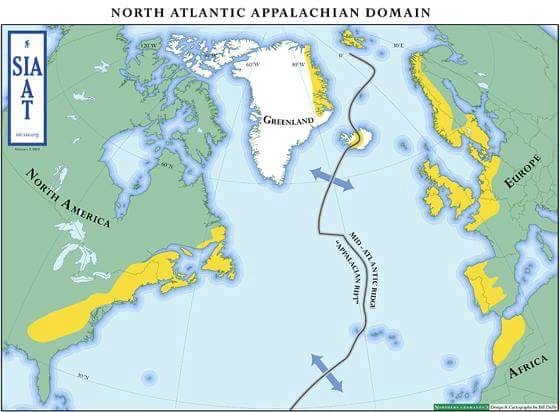
18. The Rifting of Pangea and the Creation of the Atlantic Ocean
Between 200 and 190 MA, the magmatic currents within the mantle changed directions once again. The constituent tectonic plates of Pangea were pulled apart. As Gondwana, Baltica and Laurentia were pulled away from each other, rift valleys were created between them that filled with seawater.
The result of this rifting of the tectonic plates was the creation of the Atlantic Ocean and North Sea.
19. The Tectonostratigraphic Zones and Subzones of the Newfoundland Appalachians
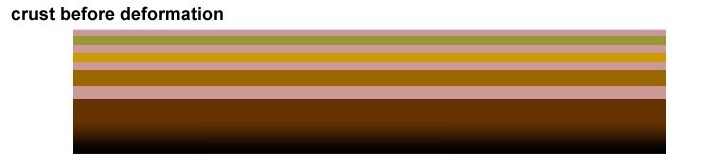
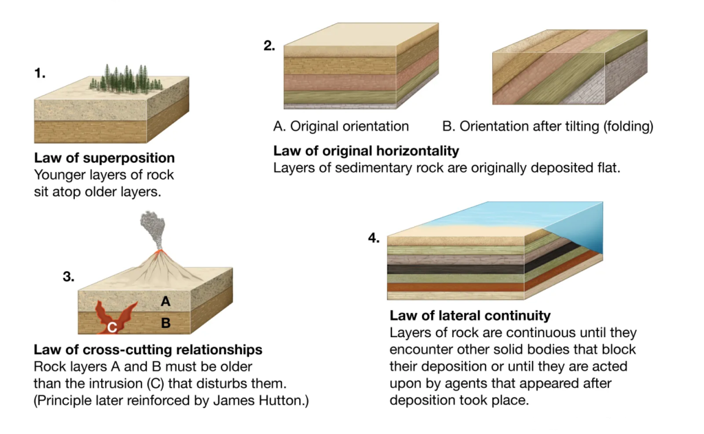
Definition: Stratigraphy Stratigraphy deals with the arrangement of layers of rock within the earth’s crust as well as the origin, composition and distribution of these layers (strata).The goal of a stratigraphic study is the definition of the layers of rock with similar geological characteristics into defined units that can be mapped and then determining when each layer of rock was deposited in that location and what was their place of origin
The guiding principal of stratigraphy is that younger layers are usually found above older layers of rock.
An important principle in the application of stratigraphy to archaeology is the “law” of superposition—the principle contends that in any undisturbed deposit the oldest layers are normally located at the lowest level. Accordingly, it is presumed that the remains of each succeeding placement of rock is left on the debris of the last.
Definition: Tectonostratigraphy
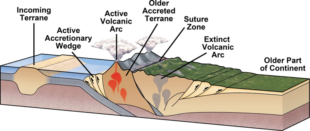
Tectonostratigraphy is a relatively new branch of stratigraphy that studies the effects of the rifting and colliding of the earth’s tectonic plates on pre-existing layers of rock. Large bodies of rock that become attached (accreted) to the margin of continental (tectonic) plates through subduction or collision with another tectonic plate are referred to as “terranes”. The size of terranes can range in size from hundreds to thousands of square kilometers. Terranes are bounded by major faults and contain rocks with geological characteristics that differ from adjacent bodies of rock.
Accreted terranes are fragments of continental or oceanic crust, including fragments of microcontinents and volcanic island arcs. These terranes did not subduct, being carved from the subducting tectonic plate and then accreted to the overriding tectonic plate (Laurentia). Orogenic belts, such as the Island of Newfoundland, are composed of numerous terranes with different geologic characteristics, origins, and histories of accretion to a continental plate.
The goal of tectonostratigraphy, within the context of gold exploration, is to define which terranes may consist of gold bearing rock and what type of gold deposits are consistent with the geological characteristics of that terrane. The study of PlateTectonics explains why there is gold in Newfoundland. Tectonostratigraphy explains where gold should be found.
The relevance of this method of identification will become apparent as we discuss the Tectonostratigraphic Zones of Newfoundland.
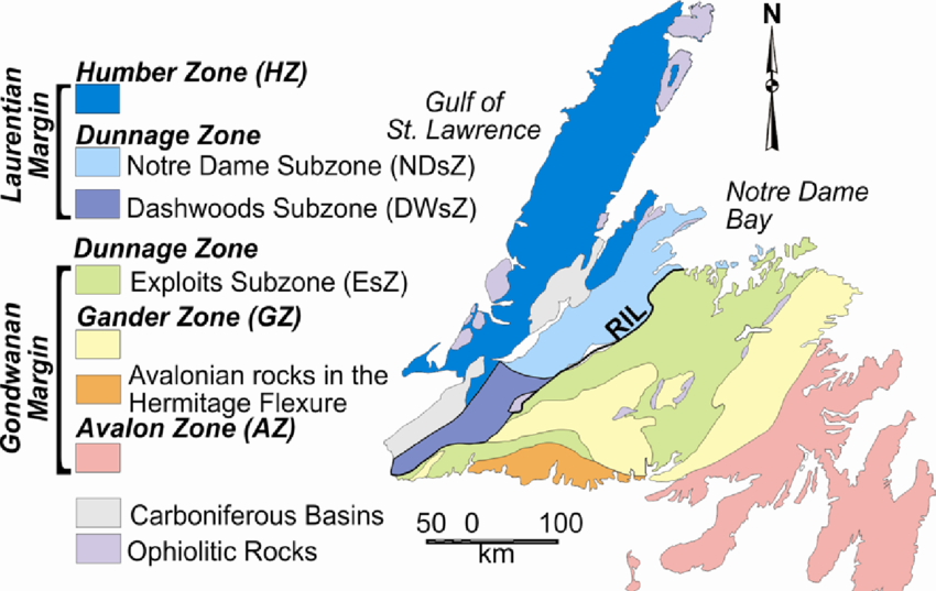
The Island of Newfoundland has four designated tectonostratigraphic zones. Running from East to West they are: 1) The Avalon Zone, 2) The Gander Zone, 3) The Dunnage Zone, 4) The Humber Zone
The Gander and Avalon Zones
The rocks of the Gander and Avalon zones are the remnants of the volcanically created micro-continents that we discussed above. The rocks are characterized by volcanic igneous rock as well as metamorphic rock (igneous rock that has been changed in its composition by the extreme pressure and heat created by its thrusting against the rock of the Dunnage Zone).
The Dunnage Zone
The rocks of the Dunnage Zone are the remains of the floor of the Iapetus Ocean and, in particular, the Central Iapetus Magmatic Province. The gold bearing rock is primarily composed of volcanic massive sulfides (VMS), typical of rock that has been created by mid-ocean rifts.
The tectonostratigraphic zones of the Island of Newfoundland are bounded by major fault and shear zones. In addition to those listed below, there are numerous fault and shear zones that lie within the boundaries of each tectonostratigraphic zoned cavities for the upward movement of hydrothermal gold-bearing fluids.
The Dunnage Zone is divided by geologists into three subzones: the Notre Dame Subzone, the Dashwoods Subzone and the Exploits Subzone. However, due to the similarities in the underlying rocks of the Notre Dame and Dashwoods Zones, some geologists refer to them collectively as the Notre Dame Subzone.
a) Notre Dame Subzone
The northeastern end of the Dunnage Zone comprises the Notre Dame Subzone, bounded to the southeast by the Red Indian Line.
Some of the underlying rock of the Notre Dame Zone is also characterized by the orogenic events associated with the Taconic Orogeny and the continental (tectonic) plate of the Iapetus Ocean subducting under the tectonic plate of Laurentia where the Taconic Orogeny had occurred.
b) Dashwoods Zone
Situated to the southwest of the Notre Dame Subzone, the rock of the Dashwoods Zone are similarly composed of remnants of the Taconic Orogeny and the Central Igneous Magmatic Province of the Iapetus Ocean. Some geologists believe that Dashwoods may have been a microcontinent that had rifted from the Laurentian tectonic plate and accreted to Laurentia again prior to the accretion of the Taconic volcanic island arc. Whatever the case, the Dashwood Zone is surrounded by major fault zones.
b) Exploits Subzone
The underlying rock of the Exploits Subzone is characterized by the orogenic events of the volcanic microcontinent of Avalonia docking with the tectonic plate of Gondwana and then subsequently accreting to the rocks of the Iapetus Ocean and the microcontinent of Ganderia that had been added to the margin of the Laurentian tectonic plate at an earlier time.
The Humber Zone
The underlying rock of the Humber Zone was primarily formed during the Grenville Orogeny. The Long Range Mountains and Gros Morne National Park are located within the Humber Zone and are reported to be have the oldest exposed rock on the planet.
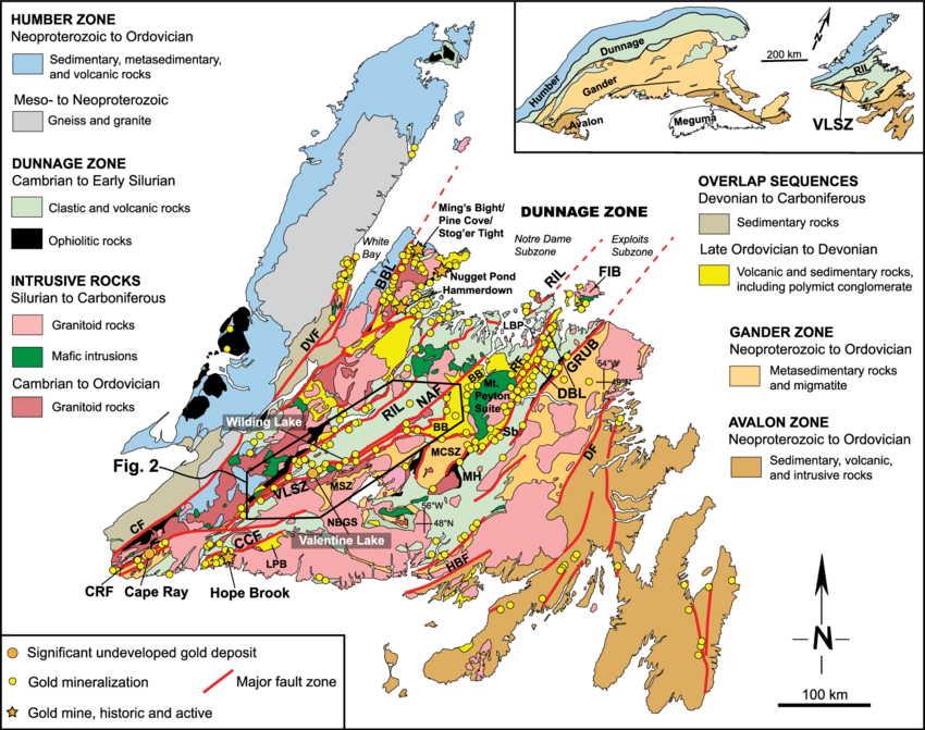
20. The Fault and Shear Zones of Newfoundland
The tectonostratigraphic zones of the Island of Newfoundland are bounded by major fault and shear zones. In addition to those listed below, there are numerous fault and shear zones that lie within the boundaries of each tectonostratigraphic zone of the Island.
1. Botwood basin-BB; 2. Baie Verte-Brompton Line-BBL; 3. Cinq Cerf fault-CCF; 4. Cabot fault-CF; 5.Cape Ray Fault Zone-CRF; 6. Dog Bay Line-DBL; 7. Dover fault-DF; 8. Doucers Valley Fault Zone-DVF; 9. Fogo Island Intrusive Suite-FIB; 10. Gander River Complex-GRUB; 11.Hermitage Bay fault-HBF; 12. Loon Bay pluton-LBP; 13. La Poile basin-LPB; 14. Mount Cormack Subzone-MCSZ; 15. Mosquito Hill gold prospect-MH; 16. Meelpaeg Subzone-MSZ; 17. Northern Arm fault-NAF; 18. North Bay Granite Suite-NBGS; 19. Red Indian Line-RIL; 20. Reach fault-RF; 21. Beaver Brook Antimony Mine-Sb; 22. Victoria Lake Shear Zone-VLSZ